
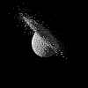
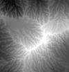
DLA-ND is an arbitrary-dimensional diffusion-limited aggregation
simulator. It creates branching, dendritic shapes in 2D, 3D, 4D, etc. using an
accelerated random walk method and spatial subdivision to accelerate
distance tests.
The newest version was released 2005-09-14.
DLA-ND homepage
dla3d was the precursor to DLA-ND, above.
It only operates in three dimensions and is significantly slower than DLA-ND.
It was first released 2003-12-05.
dla3d homepage
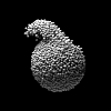
Part-ND is an arbitrary-dimensional, stand-alone particle system
and gravitational simulator written in ANSI C (mostly for my own
amusement). It utilizes an adaptive octree system for heirarchical space
subdivision and can simulate a variety of forces and boundary
conditions including self-gravitation, global gravitation,
self-contact, wall contact, and spaghetti. Version 1.4, with
some bug fixes and a Windows version, was released 2005-09-14.
Part-ND homepage
part3d was the precursor to Part-ND, above.
It only operates in three dimensions and is somewhat slower than Part-ND.
Version 1.0 was released 2003-11-21.
part3d homepage
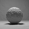
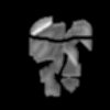
Rocktools is my frequently-used toolkit for
creation and manipulation of open and closed triangle meshes, and is ideally
suited for creating 3D meshes of rocks, landscapes, and rough shapes.
The programs now available with the toolkit are: rockcreate,
rockdetail, rocksmooth, rocktrim, and
rockerode.
Most of those programs can read Wavefront (.obj), TIN, and RAW formats,
and write to Wavefront (.obj), POV mesh (.pov),
Radiance (.rad), Renderman polygon (.rib), irregular triangular
network (.tin), and raw formats. Some programs even support surface
normal smoothing. Wow. I'm due for a new release soon.
Rocktools homepage
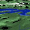
hftools is a distribution of useful tools for creation,
manipulation, and rendering of virtual landscapes using triangle
meshes instead of scalar heightfields. It includes
programs called: gtop2pgm, dem2pgm, sdts2pgm, hfscale, hfcolor,
pgmblob, pgmglacier, hf2rad, pgm2stm, tinfile, tinscale, tinsmooth,
and tin2rad.
hftools homepage


vortex2d is a 2-dimensional viscous vortex simulator, its
development has slowed, but still features
viscous decay, particle and vortex generators, image input, and other useful
output functions. From the command-line, it can produce
a series of PGM image files. (No homepage)
Download vortex2d.tar.gz
erode is a 2D erosion simulator, written by John Beale, creator of
HF-Lab, gforge, and other cool heightfield tools. I have added
export to PGM, and may add more stuff.
Download my slightly-modified
erode.tar.gz
Download John's original
er1u.tar.gz
Jump to John Beale's homepage
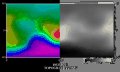
rgb2hsv is an ANSI C program that will convert a false-color, shaded
heightfield into its hue, saturation, and brightness constituent
components. It works on any PPM file and will write a PPM file.
It is most useful on heightfield images of the type found at
Views of
the Solar System. Here is the code:
rgb2hsv.tar
plates is a one-shot C program, written in 1988 by Mark Isaak,
that simulates plate tectonics/continental drift. A simple text
interface is provided, and options to export data for land
elevations, sea elevations, and mineral content in text, .ps,
and .pgm format are included. Initial continent forms are not
as nice as cdrift (below), but plates is scalable and computes
ocean depths, with mid-oceanic rifts, hot spots, for volcanoes,
and wrapping continents on a square torus.
Download plates.c
cdrift is a continental drift simulation program which incorporates
several geological principles to create a simulated model of
a super-continent break-up and reassembly cycle.
The original code is copyrighted by David Allen, and can is for Amiga, PC,
and Unix. My rewritten parts have only been tested on Linux.
The file planet.tar.gz includes source code for TEC, the
continental drift program in cdrift, and CLIM, a climate simulator.
Dave has recently packaged a Windows/Sun/Linux distribution.
Download cdrift.tar.gz
Download planet.tar.gz
Go to
Dave's World Builder page
dem2pgm takes a USGS DEM and completely converts it to a 16-bit
ASCII-encoded PGM image file. Originally dem2tga.c, by Jon Larimer.
Also available is John Beale's dem2pgm, originally by
Christopher Keane. My version is not perfect, but it uses
more information from the DEM.
Download my dem2pgm.c
Download John's dem2pgm.tar.gz
dem2rad takes a USGS DEM and writes out a Radiance-readable data
file containing all of the elevation nodes. Originally demex.c, by
Robert Smyser, then dem2rad.c, by Gilbert Leung. Recent changes
by Lars Grobe.
Download dem2rad_0.2.1.tar.gz
sdts2pgm takes a USGS SDTS-formatted DEM and completely converts it to
a 16-bit ASCII-encoded PGM image file. Originally sdts2ARC.c, by Sol
Katz. This one is perfect. Way to go Sol!
Download sdts2pgm.c
Download sdts2pgm_linux executable